
Written by Alain Lagacé
Exploration date: July 4-6, 2019
Temperature: 21 ° C day / 11 ° C night
Area: Esker Northern Divide - George River Plateau
Distance traveled: 32 km round trip
Travel: on foot and mountain bike (Fat Bike)

Highlights:
- Wildlife encounters
- Wolf dens
- Postglacial landscape
- Micro-oasis of arctic flora
- Riding a fatbike on an esker


It was last July after having planned this exploration trip at length and scrutinizing the topo maps on Google Map that I flew to the Quebec-Labrador peninsula.
The objective of this first part of the trip is to explore the Esker * Northern Divide near the Quebec-Labrador border and to determine the potential of ecotourism resources.
* An Esker is a fluvio-glacial formation in the form of an elongated, straight or sinuous moraine crest, which can reach several kilometers in length and 10 to 50 meters in height.
When I arrived in the highlands of the George River Plateau, I flew over the Esker Northern Divide up to the Dry Canyon. This low-level flyby confirmed that the crest of the Esker ridge offers miles of natural trails that can be explored by “Fat Bike”.
So I landed the float plane in a small, sheltered sandy bay near the esker and settled in to explore for a few days.
After quickly unloading the Fat Bike (Norco Bigfoot 2) from the float plane, reorganizing the interior in an RV and filling my backpack with photographic equipment, I set off to explore the Esker Northern Divide for three days.
[The Esker Northern Divide is a true natural path that winds through the postglacial landscapes of the Arctic tundra.]
I was so thrilled to be able to ride my mountain bike through the tundra landscapes that in just a few hours I had already covered several kilometers on the winding crest of the esker.
The Esker Northern Divide is a true natural path that winds through the postglacial landscapes of the Arctic tundra.
Esker Ridge is a natural promontory that rises 10 to 50 meters above the tundra and provides a great 360-degree panoramic view of the surroundings.
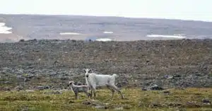
From the first kilometers I encountered traces of wolves, foxes and caribou. I could see some dens of scattered lemmings, but no colonies. I stopped in several places to scan the horizon with my binoculars and I observed caribou alone and in small groups grazing in the micro oases of greenery on the edge of the esker.
On the highest esker ridges that cross the mountain tops, I found several headlands freshly frequented by birds of prey. There were fairly recent bird pellets, probably peregrine falcons or snowy owls. On a few occasions the curious Northern Raven came to see me. It must be said that here at a little over 1,400 km from Montreal, wildlife is dominant and does not fear humans. Twice caribou came to meet me and they approached me within 20 meters.
While riding on the crest of esker I observed several micro oases of vegetation, some of which were lined with magnificent arctic wild flowers - Icelandic poppy, stemless heath, safflower saxifrage, arctophile willow and several other plants and moss typical of the Arctic regions.
I followed long tongues of snow on the edge of the esker and crossed imposing erratic blocks which rested in precarious balance on small stones.
On a sandy ridge facing east near the esker top I discovered a site of ancient wolf dens, and one that has been active for the past week.
The almost fresh traces of the pups show that the den was occupied just a few days ago.
In 2020 the exploration continues and I will be there sooner!
Discover the package: Fat-Bike Adventure on the Esker Northern Divide
For more information or to book:
Alain Lagacé - alain@goldenpeninsulatours.com